100% Online
Complete your Penn State course work at your own pace and 100% online.
Application deadline
Credits and costs
10-Week Terms
Finish your program faster with accelerated 10-week terms.
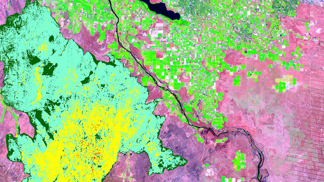
Gain Skills to Excel in the Field of Spatial Data Science
Design and implement new methods for analyzing and visualizing spatial data.
Use the Python programming language to write and modify scripts that add greater functionality to desktop GIS tools.
Automate repetitive GIS tasks, customize GIS interfaces, and share geospatial software development work with others.
Create new products to solve real-world problems by developing skills in programming, spatial analysis, and cartography.
Demonstrate effective scientific writing, presentation, and cartographic communication skills.
Online Courses in Spatial Data Science
Online Courses in Spatial Data Science
The courses in this online spatial data science graduate program are designed to equip you with the skills and knowledge needed to harness the power of spatial data for impactful decision-making and innovative solutions.
You can gain an advanced understanding of spatial data concepts, tools, and applications in this unique online GIS program that emphasizes hands-on learning using practical exercises, real-world projects, and state-of-the-art tools. With industry-relevant skills in hand, you’ll be better prepared to create new spatial data science software, analytical methods, and cartographic products to help visualize spatial connections and solve location-based problems.
Prescribed Courses (9 credits)
- 3credits
Customizing GIS software to extend its built-in functionality and to automate repetitive tasks.
- Prerequisite
GEOG 484 or GEOG 884 or equivalent experience
- 3credits
Theory and practice of cartographic design, emphasizing effective visual thinking and visual communication with geographic information systems. Technologies: ArcGIS Pro, Mapbox Studio, QGIS
- Prerequisite
GEOG 484 or permission of the program
- 3credits
Choosing and applying analytical methods for geospatial data, including point pattern analysis, interpolation, surface analysis, overlay analysis, and spatial autocorrelation.
- Prerequisite
GEOG 485 or GEOG 486 or GEOG 487
Elective Courses (select 6 credits)
- 3credits
Focuses on the science of analytical reasoning mediated through human-centered interactive geographic visualization and computational methods; provides students with hands-on experience solving complex problems through the design, implementation, and application of geovisual analytics tools.
- 3credits
Traces the roots of spatial data science ethics in moral philosophy, professional ethics frameworks, and critical studies. Students will critique legal and policy issues in the U.S. and abroad.
- 3credits
Systematic approach to requirements acquisition, specification, design, and implementation of geospatial information systems.
- Prerequisite
GEOG 484
- 3credits
Design, development, and implementation of web mapping applications using OGC standards and open source software.
- 3credits
Focuses on theoretical discussions on relevant topics and methods used in spatial data science, as well as on applying a range of spatial data science skills and tools to solve real-world problems and model geographic phenomena.
- 3credits
Advanced topics in remote sensing and image processing, including new sensors, applications, and decision-making.
Course Availability
If you're ready to see when your courses will be offered, visit our public LionPATH course search (opens in new window) to start planning ahead.
Start or Advance Your Geospatial Career
Start or Advance Your Geospatial Career
In today’s data-driven world, spatial data scientists can transform vast amounts of raw data into compelling visual stories. This ability to analyze and interpret geographical data is revolutionizing how decisions are made across a wide range of industries, leading to a variety of career opportunities.
Career Opportunities for Graduates
This program helps prepare graduates to work at the forefront of the industry, where geographic information systems (GIS) and spatial analysis intersect with the principles of data science, visualization, and programming.
Spatial data scientists, GIS analysts, and geospatial programmers often leverage the power of location-based insights to address challenges in areas like:
- urban planning
- business and product development
- transportation and logistics
- public health
- public safety and national defense intelligence
- conservation and environmental resource management
- emergency response
- energy utilities
Career Services to Set You Up for Success

From the day you're accepted as a student, you can access resources and tools provided by Penn State World Campus Career Services to further your career. These resources are beneficial whether you're searching for a job or advancing in an established career.
- Opportunities to connect with employers
- Career counselor/coach support
- Occupation and salary information
- Internships
- Graduate school resources
Ready to Learn More?
Get the resources you need to make informed decisions about your education. Request information on this program and other programs of interest by completing this form.
Ready to take the next step toward your Penn State graduate certificate?
Costs and Financial Aid
Costs and Financial Aid
Learn about this program's tuition, fees, scholarship opportunities, grants, payment options, and military benefits.
Costs and Financial Aid
Graduate Tuition
Graduate tuition is calculated based on the number of credits for which you register. Tuition is due shortly after each semester begins and rates are assessed every semester of enrollment.
2024–25 Academic Year Rates
| How many credits do you plan to take per semester? | Cost |
|---|---|
| 11 or fewer | $1,027 per credit |
| 12 or more | $12,325 per semester |
2025–26 Academic Year Rates
| How many credits do you plan to take per semester? | Cost |
|---|---|
| 11 or fewer | $1,037 per credit |
| 12 or more | $12,448 per semester |
Paying for Your Certificate
Students pursuing this certificate may be eligible for federal student aid. Find more information from the online geospatial education program office.
Additionally, Penn State offers many ways to pay for your education, including an installment plan and third-party payments. Penn State World Campus also offers an Employer Reimbursement and Tuition Deferment Plan. Learn more about the options for paying for your education.
Students pursuing a degree and meeting all other eligibility requirements may qualify for financial aid.
Military Benefits
Military service members, veterans, and their spouses or dependents should explore these potential military education benefits and financial aid opportunities, as well.
Additional Cost of Attendance Details
To view the detailed list of cost of attendance elements:
- visit the Tuition Information site
- click the plus sign to expand the table
- select a semester from the World Campus row
Technical Requirements
Review the technical requirements for this program.
A Head Start toward a Master’s Degree

A Head Start toward a Master’s Degree
Not only can this program help create opportunities in your career, it can also give you a solid head start toward a master’s degree.
Degree Programs Related to This Certificate
While the Graduate Certificate in Spatial Data Science serves as an excellent stand-alone credential, successfully completed credits may be applied toward one of our GIS–related graduate degrees, should you apply and be accepted into the program:
The M.S. in Spatial Data Science can help you leverage vast amounts of geospatial data to identify patterns, develop insights, and solve location-based problems. Prepare to work where GIS and spatial analysis intersect with the principles of data science, visualization, and programming.
Learn more about the Master of Science in Spatial Data ScienceThis online GIS master’s degree program can help you uncover insights and relationships to improve strategic decision making. Learn to apply industry best practices and the latest mapping tools to integrate, visualize, and interpret geospatial data. Customize your GIS degree program with 30 online courses.
Learn more about the Master of Geographic Information SystemsCombine intelligence analysis with geospatial science and technology to gain situational awareness and provide a decisive advantage in preventing and responding to homeland security threats. This online degree program can help improve the accuracy of your organization's most critical intelligence assessments.
Learn more about the Master of Professional Studies in Homeland Security – Intelligence and Geospatial Analysis OptionSet Your Own Pace with Flexible 10-Week Terms
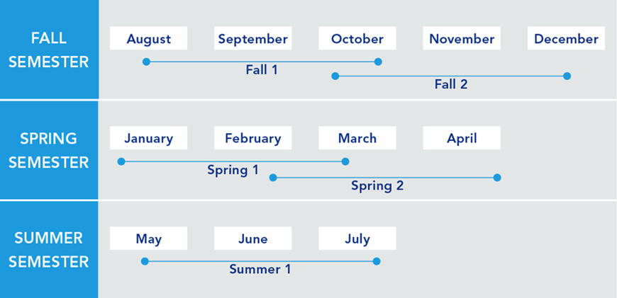
Set Your Own Pace with Flexible 10-Week Terms
This flexible program is composed of five 10-week terms — with two terms that partially overlap in fall and spring, and one in the summer. You can choose to schedule your courses without any overlap or take as many courses as possible to finish sooner, making it possible to finish the certificate in a year or less.
Students in graduate geospatial programs typically take one course per 10-week term.
Accelerated Admission to an Online Master's Program
Accelerated Admission to an Online Master's Program
Any geospatial certificate student who earns a 3.67 grade-point average or higher after completing the first three courses of the certificate may qualify for accelerated admission to the Master of Geographic Information Systems, Master of Science in Spatial Data Science, or Master of Professional Studies in Homeland Security – Intelligence and Geospatial Analysis Option.
Advantages of accelerated admissions:
- No GRE test, professional experience, or letters of recommendation required
- Admission decisions are made on a rolling basis, year-round
Convenient Online Format
This program's convenient online format gives you the flexibility you need to study around your busy schedule. You can skip the lengthy commute without sacrificing the quality of your education and prepare yourself for more rewarding career opportunities without leaving your home.
A Trusted Leader in Online Education

Penn State has a history of more than 100 years of distance education, and World Campus has been a leader in online learning for more than two decades. Our online learning environment offers the same quality education that our students experience on campus.
Information for Military and Veterans

Are you a member of the military, a veteran, or a military spouse? Please visit our military website for additional information regarding financial aid, transfer credits, and application instructions.
Note: This program is under review for GI Bill® eligibility, and you may experience delays attempting to use GI Bill benefits toward this program until it has been officially approved.
GI Bill® is a registered trademark of the U.S. Department of Veterans Affairs (VA). More information about education benefits offered by VA is available at the official U.S. government website at https://www.benefits.va.gov/gibill.
How to Apply to Penn State

How to Apply to Penn State
Apply by August 1 to start August 13
Application Instructions
Deadlines and Important Dates
Complete your application and submit all required materials by the appropriate deadline. Your deadline will depend on the semester you plan to start your courses.
Fall Deadline
Apply by August 1 to start August 13Spring Deadline
Apply by December 15 to start January 7Summer Deadline
Apply by April 15, 2026
Steps to Apply
For admission to the J. Jeffrey and Ann Marie Fox Graduate School, an applicant must hold either (1) a baccalaureate degree from a regionally accredited U.S. institution or (2) a tertiary (postsecondary) degree that is deemed comparable to a four-year bachelor's degree from a regionally accredited U.S. institution. This degree must be from an officially recognized degree-granting institution in the country in which it operates.
Work Experience — Applicants are expected to have intermediate-level experience working with GIS in a professional setting at the time of their application. Alternatively, course work to establish that prerequisite knowledge is available through our Postbaccaulaureate Certificate in GIS program, also offered online through Penn State World Campus. Please email the program office at [email protected] with questions.
You will need to upload the following items as part of your application:
Official transcripts from each institution attended, regardless of the number of credits or semesters completed. Transcripts not in English must be accompanied by a certified translation. If you are a Penn State alum, you do not need to request transcripts for credits earned at Penn State but must list Penn State as part of your academic history.
English Proficiency — The language of instruction at Penn State is English. With some exceptions, international applicants must take and submit scores for the Test of English as a Foreign Language (TOEFL) or International English Language Testing System (IELTS). Minimum test scores and exceptions are found in the English Proficiency section on the Fox Graduate School's "Requirements for Graduate Admission" page. Visit the TOEFL website for testing information. Penn State's institutional code is 2660.
GRE and GMAT test scores are NOT required.
To begin the online application, you will need a Penn State account.
Create a New Penn State Account
If you have any problems during this process, contact an admissions counselor at [email protected].
Please note: Former Penn State students may not need to complete the admissions application or create a new Penn State account. Please visit our Returning Students page for instructions.
You can begin your online application at any time. Your progress within the online application system will be saved as you go, allowing you to return at any point as you gather additional information and required materials.
- Choose Enrollment Type: "Certificate Admission"
- Choose "WORLD CAMPUS" as the campus
Checking Your Status
You can check the status of your application by using the same login information established for the online application form.5. Complete the application.
Admissions Help
If you have questions about the admissions process, contact an admissions counselor at [email protected].
Contact Us

Contact Us
Have questions or want more information? We're happy to talk.
To learn more about the Graduate Certificate in Spatial Data Science, please contact:
Julene Santiago, Geospatial Portfolio Program Assistant
Penn State College of Earth and Mineral Sciences
[email protected]
Phone: 814-865-2557
Learn from the Best
Learn from the Best
The Graduate Certificate in Spatial Data Science is developed by Penn State's College of Earth & Mineral Sciences and delivered through Penn State World Campus. Our courses are taught by distinguished faculty who have special training and experience teaching in an online environment.
Faculty
Anthony C. Robinson, Ph.D.
- DegreePh.D., Geography, Penn State
- DegreeM.S., Geography, Penn State
- DegreeB.S., Applied Geography, East Carolina University
Dr. Anthony C. Robinson, professor of geography, serves as the director of online geospatial education at Penn State. He is also the faculty director for the GeoGraphics Lab in the Department of Geography and former president of the North American Cartographic Information Society (NACIS). Dr. Robinson is a cartographer who designs and evaluates geovisualization tools to improve geographic information utility and usability. He has worked in epidemiology, crisis management, national security, and education domains to develop and evaluate new methods for visualizing spatial data.
Ryan Baxter
- DegreeM.S., Geography, Penn State
- DegreeB.A., Geography and Environmental Sciences, Northwestern University
Ryan Baxter advises students and teaches courses in topics including renewable energy, environmental applications of GIS, cloud and server GIS technologies, and introductory geographic information concepts. He is active in technical research projects involving spatial databases, online data discovery tools, interactive mapping applications, and cloud-based GIS services. He is also engaged in research investigating the spatial modeling of land use change, quantifying the amount of land available for bioenergy feedstocks, and assessing the suitability and productivity of energy crops.
Amy Burnicki
DegreePh.D., Natural Resources & Environment, University of MichiganDr. Amy Burnicki is an associate teaching professor in the Department of Geography. Her research applies spatial data analysis, spatial statistics, and quantitative modeling approaches in the field of land change science and in transportation and environmental engineering applications.
James Detwiler
- DegreeM.S., Geography, University of Delaware
- DegreeB.S., Earth Science, Penn State
James Detwiler is in a 100% teaching appointment and specializes in GIS programming. He teaches GEOG 485: GIS Programming and Automation; GEOG 863: Web Application Development; and GEOG 868: Spatial Database Management. His research interests are in the areas of applied GIS and climatology.
Brandi Gaertner
DegreePh.D., Forestry and Natural Resources, West Virginia UniversityDr. Brandi Gaertner, assistant teaching professor of spatial data science in the online geospatial education program, joined the Penn State faculty in 2021. Dr. Gaertner is a climate change hydrologist and GIS analyst. Her research focus is on evaluating historical and future impacts of climate change on surface streamflow and climate variables such as precipitation and temperature.
Panagiotis Giannakis
- DegreePh.D., Geosciences, University of Arkansas
- DegreeM.S., Human Resource Management, Athens University of Economics & Business
Panagiotis Giannakis is an Assistant Teaching Professor in the Department of Geography and the Dutton e-Education Institute within the College of Earth & Mineral Sciences. He received his PhD from the University of Arkansas, where he also maintained a key role in the advancement of the Online Geospatial Certificate program. His research interests lie at the intersection of Economic Geography, Strategic Management, and Social Networks. More specifically, Panagiotis’ research focuses on the relationship between organizational and physical and/or social network space.
Adrienne Goldsberry
- DegreeM.A., Geography, University of California - Santa Barbara
- DegreeB.A., Geography, The University of Texas at Austin
Adrienne Goldsberry is an instructor as well as adviser for students in the Postbaccalaureate Certificate in Geographic Information Systems program. Before joining Penn State, she was an online instructor for Michigan State University's Department of Geography, Environment, and Spatial Sciences and managed its online Professional Certificate in GIS. She also worked as an urban planner for jurisdictions in California, Texas, and Michigan.
Fritz Kessler
- DegreePh.D., Geography, University of Kansas
- DegreeM.S., Geography, Penn State
- DegreeB.S., Geography, Ohio University
Dr. Fritz Kessler's teaching interests include cartography, geographic visualization, map projections, spatial analysis, land surveying, geography of health, and statistics. His research interests include map projections, geographic visualization, history of cartography, and cognitive cartography.
Beth King
- DegreeM.Ed., Adult Education, Penn State
- DegreeB.S., Geography, Penn State
Beth King is co-author and instructor of GEOG 483: Problem-Solving with GIS; GEOG 482: Making Maps that Matter with GIS; and GEOG 597G: Challenges in Global Geospatial Analytics. She is assistant program manager for Online Geospatial Education and maintains regular communication with students in the MGIS degree program to identify their questions and concerns. Previously, she worked as a GIS analyst for a private water/wastewater engineering firm, where she managed a wide range of GIS projects, from turnkey sanitary sewer conversion to 911 rural addressing.
Karen Schuckman
- DegreeM.S., Geographic Information Systems, Penn State
- DegreeB.A., Liberal Arts, Penn State
- DegreeB.S., Meteorology, Penn State
Karen Schuckman's teaching and research interests include applications of airborne and spaceborne remote sensing to topographic mapping, land-use/land-cover analysis, positional accuracy assessment of remotely sensed base map data products, and other geospatial applications.
Marcela Suárez
DegreePh.D., Geography, University of California, Santa BarbaraDr. Marcela Suárez is an assistant teaching professor in the Department of Geography and the John A. Dutton Institute for Teaching and Learning Excellence within the College of Earth and Mineral Sciences. Dr. Suárez 's research interests lie at the intersection of geographic information science, cartography, and emergency management.
Gregory Thomas
- DegreePh.D., Administration and Leadership Studies, Indiana University of Pennsylvania
- DegreeMPA, Penn State
- DegreeB.S., Criminal Justice, Shippensburg University of Pennsylvania
Dr. Gregory Thomas has experience developing intelligence for decision-makers, supervising the analytical process, and providing team guidance. He also has experience teaching intelligence and analytical techniques to college students as well as intelligence analysts and law enforcement personnel. He has developed operational intelligence to support criminal investigations and anti-terrorism activities, and has selected, trained, and supervised analysts in a criminal intelligence center. His teaching and research focus on geospatial intelligence analysis, homeland security, and criminal intelligence.
Michelle Zeiders
- DegreeM.S., Geoenvironmental Studies, Shippensburg University of Pennsylvania
- DegreeB.S., Public Administration, Shippensburg University of Pennsylvania
Michelle Zeiders teaches GEOG 483: Problem-Solving with GIS; GEOG 484: GIS Database Development; and GEOG 487: Environmental Applications of GIS. She has been teaching introductory and software-intensive GIS courses since 1998. Prior to joining the geospatial education program, she worked as a GIS programmer/instructor for the Penn State Population Research Institute, a GIS project manager/instructor for the Institute for Transportation Research and Education at North Carolina State University, a GIS project manager at a private civil engineering firm, and a GIS analyst at MapQuest.